About Downswood, Kent
(See separate tab 'History of Downswood' by Cllr Raj Rajalingam for further info)
Situated two miles from Maidstone, the county town of Kent, Downswood lies in the extreme northwest of the ecclesiastical parish of Otham and is now a civil parish in its own right. It is bounded to the north by the River Len, on which stood two mills, both water driven. One was a corn mill mentioned in Doomsday and the other a fulling mill built around 1550. The corn mill stood on the south side of the River Len at the junction of Spot Lane and Willington Street and must have been rebuilt several times over the centuries until falling into disuse in the middle of the nineteenth century. The fulling mill stood a little upstream where a small stone bridge still crosses the river. The fulling process cleaned and degreased the woollen cloth after weaving and finally textured it.
Immediately to the south of Downswood lies Otham Church (St Nicholas) with a Norman nave, a 12th century tower and a shingled roof. To the east lies a wealden hall house, now a wedding venue incorporated into the Orchard Spot (formerly a public house), which was built around 1450 as a farm house and originally known as Owle Hole.
The area between these landmarks is the land on which Downswood came to be built and which up until the 1930s was farmed. By the river was pasture and on higher land were fruit orchards and cobnut platts. Hops were important but there were few arable crops grown in this relatively small area. Close by the old corn mill watercress beds flourished.
Just before the second World War most of the area became a ragstone quarry. Much of the stone was taken by lorry to the Weald of Kent and Romney Marsh for building airfields and roads preparing for the invasion of France. Quarrying ceased in the 1970s.
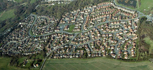
Constructed in the 1980s, the housing development covers 88.96 acres and forms the most densely populated parish within the Maidstone Borough Council area. It was granted its independence with the formation of the Parish Council in 1987. Within the Parish there is a community centre and a parade of shops. To the northeast lies Mallards Open Space which includes a lake, play and sports area.


.jpg)


